skip to main |
skip to sidebar
Camooweal to Alice
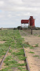
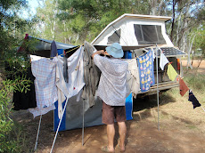
This last stage of our journey, which ends the first part of this year’s tour, has been everything a holiday on the move should be. We are grinning from ear to ear. Camooweal is a so called suburb of Mt Isa, being administered from the mining town. That makes the 200km road joining the two places the world’s longest main street, and of course Camooweal makes the most of it. On that basis we had assumed a decent supermarket for restocking, but no, the postman drives every day into Mt Isa to collect the mail, and also the day’s supplies for the shop! But we bought up as best we could in preparation for a long sojourn “out of range”.


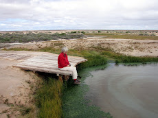
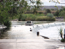
 The Sandover Hwy was in good shape and we made good time, turning south again that afternoon on another back track leading to the Plenty Hwy. Our next free camp was near the Box Hole meteorite crater where we had another wonderful dinner under the stars all on our own. Then came the wide and braided Plenty River, with deep gravelly sand, a shallow pool to wade and a steep bank immediately after it. This was the only real challenge of the journey and we lowered the tyres to 15psi and dropped as many branches across the pool as we could find. All was well and with a short run and plenty of momentum the 1200kg rig was no problem.
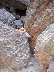
The corrugations were worse, but not an issue, as we turned west again on the Plenty Hwy, to duck off south again just 60kms later on the Cattle Water Pass Track. It was Saturday and nobody was around to ask about the conditions we were to face. There was a footy match on. We even drove three kilometres up a station driveway to find ourselves on an agricultural version of the Marie Celeste. So we bravely moved on to the track that takes you to a camp site at Old Ambalindum.
The Sandover Hwy was in good shape and we made good time, turning south again that afternoon on another back track leading to the Plenty Hwy. Our next free camp was near the Box Hole meteorite crater where we had another wonderful dinner under the stars all on our own. Then came the wide and braided Plenty River, with deep gravelly sand, a shallow pool to wade and a steep bank immediately after it. This was the only real challenge of the journey and we lowered the tyres to 15psi and dropped as many branches across the pool as we could find. All was well and with a short run and plenty of momentum the 1200kg rig was no problem.
The corrugations were worse, but not an issue, as we turned west again on the Plenty Hwy, to duck off south again just 60kms later on the Cattle Water Pass Track. It was Saturday and nobody was around to ask about the conditions we were to face. There was a footy match on. We even drove three kilometres up a station driveway to find ourselves on an agricultural version of the Marie Celeste. So we bravely moved on to the track that takes you to a camp site at Old Ambalindum.


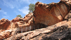
 But from an architectural point of view there is unfortunately no local vernacular in the housing, rather more of the same project homes off the same tired “drawing boards”. However if you go to the oldest buildings that predate Alice itself, the Old Telegraph Station, you see sound, appropriate, well sited and fine buildings that should have been the basis for a beautiful local architecture. Ironic really. Very Australian.
We met up with new chums Andrew and Prue again, who so warmly drew us into their circle of activity with a dinner with their colleagues and friends followed by some very powerful star gazing through Andrew’s self tracking telescopes, with a warming brazier to keep us from shivering. The van has been lodged at a remote private property outside town and the car is with A & P. We boarded QF 767 on Saturday, crossed the Simpson dusted with green, and a brimming Lake Eyre, with our noses glued to the Perspex, and here we are. Returning to a misty and dripping house to find everything as it should be, but even some more growth in the garden, is satisfying. Next step is Andy and Michelle’s wedding in Fiji next week!
But from an architectural point of view there is unfortunately no local vernacular in the housing, rather more of the same project homes off the same tired “drawing boards”. However if you go to the oldest buildings that predate Alice itself, the Old Telegraph Station, you see sound, appropriate, well sited and fine buildings that should have been the basis for a beautiful local architecture. Ironic really. Very Australian.
We met up with new chums Andrew and Prue again, who so warmly drew us into their circle of activity with a dinner with their colleagues and friends followed by some very powerful star gazing through Andrew’s self tracking telescopes, with a warming brazier to keep us from shivering. The van has been lodged at a remote private property outside town and the car is with A & P. We boarded QF 767 on Saturday, crossed the Simpson dusted with green, and a brimming Lake Eyre, with our noses glued to the Perspex, and here we are. Returning to a misty and dripping house to find everything as it should be, but even some more growth in the garden, is satisfying. Next step is Andy and Michelle’s wedding in Fiji next week!


 The Sandover Hwy was in good shape and we made good time, turning south again that afternoon on another back track leading to the Plenty Hwy. Our next free camp was near the Box Hole meteorite crater where we had another wonderful dinner under the stars all on our own. Then came the wide and braided Plenty River, with deep gravelly sand, a shallow pool to wade and a steep bank immediately after it. This was the only real challenge of the journey and we lowered the tyres to 15psi and dropped as many branches across the pool as we could find. All was well and with a short run and plenty of momentum the 1200kg rig was no problem.


 But from an architectural point of view there is unfortunately no local vernacular in the housing, rather more of the same project homes off the same tired “drawing boards”. However if you go to the oldest buildings that predate Alice itself, the Old Telegraph Station, you see sound, appropriate, well sited and fine buildings that should have been the basis for a beautiful local architecture. Ironic really. Very Australian.
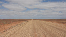


fabulously informative - what a great trip you have been having - have been following your travels on Google earth. Am sure you will have a great time in Fiji - what a contrast. Love D & C
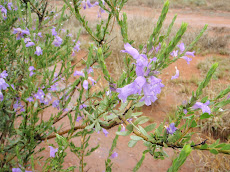
ReplyDeleteWhat a great read on a freezing wet afternoon down south. Rather rivetting on the track to Old Ambalindum. Nearly as exciting as the mudslides on my bike in horizontal rain and we now have grey thrushes on the porch singing love songs but nothing to compare to bower birds making eyes to the lady in blue
ReplyDelete